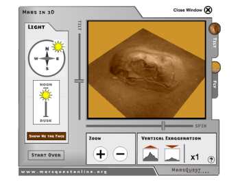
How'd we do it?
Other 3D models on this site were created with
MOLA data. But the face is too small for that: Instead,
the elevation data for this model was calculated
from images by Malin Space Systems. They took different
images of the face and used the shading of the light
to determine slopes, and from that elevation. With
that elevation data we can create a 3D model of
the face.
Next, we drape onto the model a high resolution
overhead image of the Face from the Mars Global
Surveyor spacecraft. Combined, these let you explore
the Face in 3D.
|
More like this
You can explore more parts of Mars in 3D on this
site. You can either start from the top at the Tour,
or go straight to these parts of Mars:
Explore More
The
Malin Space Systems press release on the Face. |