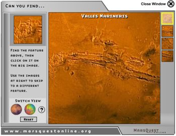
About the images
This activity uses two images of Valles Marineris. The first
combines images taken in the 1970s by the Viking orbiters and
in the 1990s by the Mars Global Surveyor (MGS) orbiter. The Viking
orbiters took color images. MGS takes higher resolution images,
but they're black and white. This image combines both to create
a high resolution, color image.
The second is colored based on its elevation: blue is lower,
green or yellow is higher. The elevation image was created using
data from the Mars Orbiting Laser Altimeter (MOLA) onboard MGS.
MOLA bounces a laser off the surface of the planet, then times
how long it takes for the beam to return to the spacecraft. From
that it can calculate its distance from the surface to an accuracy
of a little over a foot. MOLA does this over and over as it orbits,
eventually building up enough data for a global elevation map
of the entire planet.
If you're looking for features that vary in elevation (like flood
channels), this kind of map can make them much easier to see.